Wednesday, April 29, 2015

Moving Day to Wells, Nevada (mostly pictures)

Location: Angel Lake RV Park (el 5,700 ft); Wells, Nevada

(click pictures to enlarge)
(all pictures taken with Nokia Lumia 929 Cell Phone)

I chose Wells, Nevada as a stop-over on my way to Utah. The Humbolt Mountain Range is very close to Wells with a mountain lake that is easily accessible. It is closed during the winter but I was hoping that due to the mild winter, it may be open. I was wrong. I was able to drive to within about 2 miles of the lake before getting to the "road closed barricades". The road looked clear for as far as I could see and thoughts of around the barricades crossed my mind. It was kind of ironic because in my career as a highway engineer I had seen what can happen to people that ignore these type of signs. It's a good thing I obeyed by instincts and didn't go around the barricades because on the way down the mountain, I passed a Sheriff's Deputy on the way up. It would have been embarrassing for me to have been cited for going around barricades and I know several people back in Louisiana that would have given me much grief about it. :)

Even with the lake closed, there were some fantastic views of the valley and adjacent mountains, many of which were snow-capped. 

Tomorrow is moving day and I will be in Salt Lake City tomorrow. From there, I will check the weather forecast before deciding to head north to Yellowstone or south to a couple National Parks in southern Utah to await better weather in Yellowstone.

This is the countryside just east of Winnemucca. Looking into one of the valleys


The sky put on a show while I was heading directly to the mountains

It's hard to see but there is a long train out there somewhere, plus some nice mountain tops

Notice the remote sending weather station on the right side. It is probably sending data to the nearest State Highway Office.

Notice the red pole on the left side of the road. It marks the location of the road when the snow piles up.

Another good view.

Pretty mountains in the distance with a sign to a ominous place.

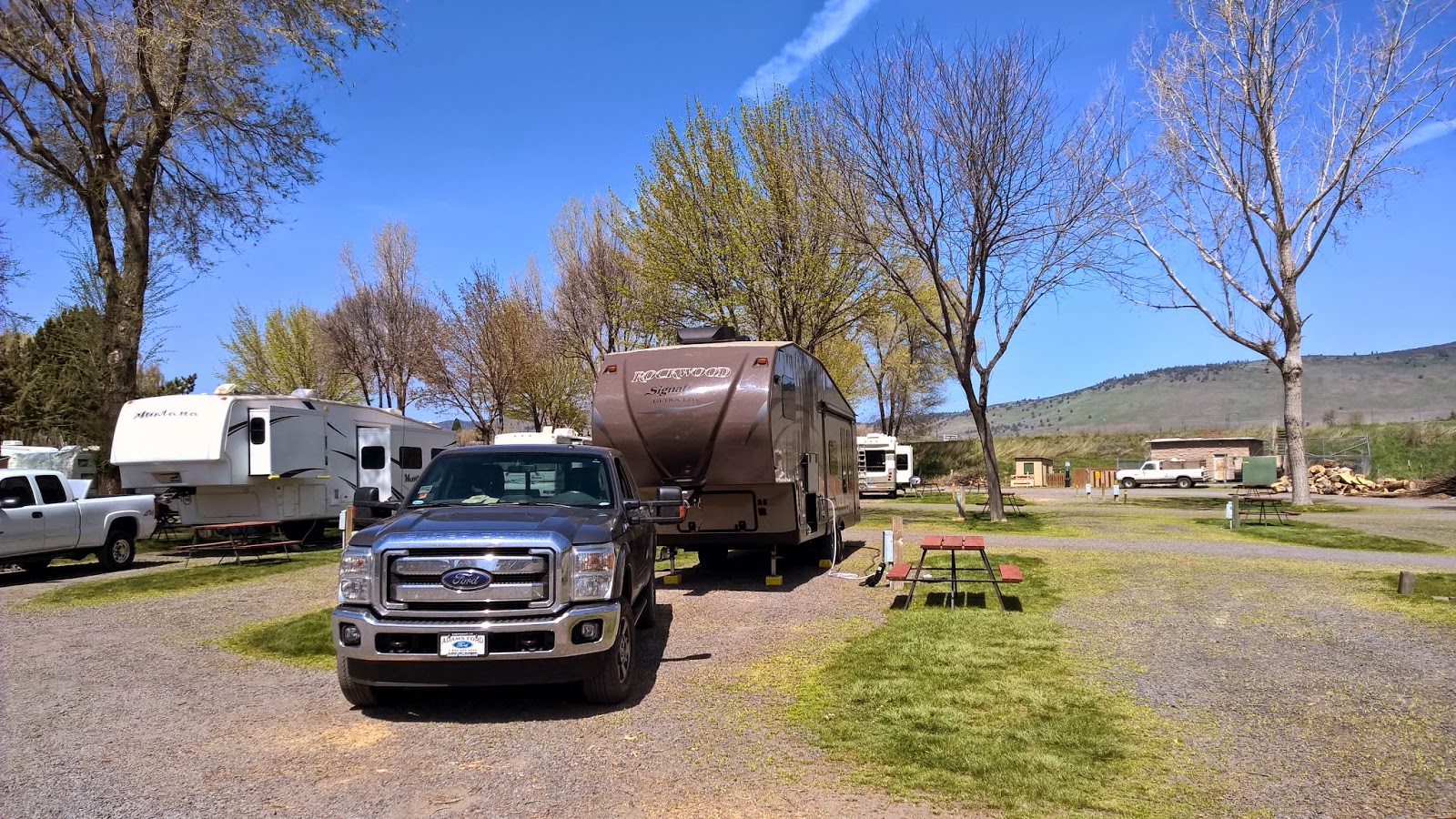
Angel Lake RV Park campsite. Nice and level with full hook-ups.

The East Humboldt Range about 6 miles from the campground.

More of the East Humboldt Range. I couldn't decide between this picture and the one above.

A panorama view of the Humboldt Range on the right.

Nice road heading in the right direction

Nice views everywhere

Ut-oh

Another panorama view

This is a panorama view of Wells, Nevada. Notice on the right side, that is Interstate 80 towards Salt Lake City. I'll be heading that way tomorrow.
Ya'll take care of each other. I'll Cya down the road.

Monday, April 27, 2015

On A Journey With Some Destinations Along The Way

Location: New Frontier RV Park (el 4,500 ft); Winnemucca, Nevada

(click pictures to enlarge)
(all pictures taken with Nokia Lumia 929 Cell Phone)

There are several quotes from famous people about destinations and the journey to get there. They want to remind us the journey is just as important as the destination. To me, the two are the same. The main purpose of my travels is to see new things. I pick places I want to see and head in that direction, but along the way, there are many things to see that I didn't know about or plan to see. Since I don't plan to permanently stop at any particular destination any time soon, I guess I'm on a journey with some destinations along the way.

That is why I enjoy moving days, because I know there will be new things to see down the road. I always keep my cell phone close by and have gotten pretty good at steering and taking pictures through the windshield. If I get pulled over by the police; I hope they buy my argument that I wasn't texting and driving, I was simply and innocently taking a picture. I also like documenting the changing landscape as I pass through an area. Years from now, as my mind starts to fade, I am hoping that just the sight of some of these pictures will bring back the feelings I had when I took them. It has become a Pavlovian response that whenever I say "Wow", I then reach for my cell phone camera.

Yesterday's journey on moving day was a surprise. There were several things along the way that I didn't expect, such as snow-capped mountains. I didn't read up on the geography of northern Nevada because I expected it to be a flat and barren desert all the way across to Utah. Well, there is a lot of desert and barren-ness (sp), but it is not everywhere, and it has it's own beauty. 

The road was smooth, the temperature a little cool, no heavy winds and the sky was big and bright with puffy white clouds. It was a good day to be traveling.

I'm camped at Winnemucca, Nevada. I stopped here because it fit my travel distance of between 150 and 200 miles on moving days. It is also a cool sounding name and mentioned in an old Johnny Cash song, "I've Been Everywhere". It is named after a Paiute Indian Chief and is the only town in Nevada named for an Indian. It is an interesting story how he got his name. Before many whites were in this area, a few prospectors met the Indian chief and he was only wearing one moccasin, which in the Paiute language is "mu-cha". The prospectors thought this was funny and called him "wan-na-mu-cha". The old Indian liked the name and it stuck. He was forever after called Winnemucca. He and his daughter, Sarah, became out-spoken advocates for the American Indians in general and the Paiutes in particular. His daughter met with President Haynes in 1880 and discussed Indian Affairs. She also was the first Female Indian author to have a book published. Her statue is one of two that the state of Nevada sent to Washington D.C. as part of the National Statuary Hall Collection. This is the kind of information I like to stumble over on my journeys to somewhere.


This was the view as I was pulling out of the campground at Reno. 

I was a little surprised by the rolling hills instead of desert. 

It did flatten out quickly, and thought this view would be the same all the way across Nevada. I was wrong. 

Dry lake beds

The land turned to scrub brush.

Dry lake bed, under a bright sky with snow-capped mountains?? in the background.

The snow-capped mountains getting closer. I couldn't see any pass or "saddle" to cross them.

I like this picture. I don't know who that is in the RV ahead, but to me, they represent all RV travelers as they head to "parts unknown".


I saw this long freight train as he was heading west. This location is very close to, if not actually on, the original Transcontinental Railroad which was completed in 1869. 

Nice mountain view from the rest stop close to Winnemucca.

The view from my campsite to the mountains to my south.

The view out the door of Liberty looking to the north.

I will be moving on tomorrow. My plans while here is to get a prescription refilled at Walmart and maybe an oil change for Freedom since I saw a Ford dealer in town. I'm not excited about getting an oil change on a Monday, but I'm not sure when the next opportunity will arise and I'm right at the mileage for a change.

Ya'll take care of each other. I'll Cya down the road.

Saturday, April 25, 2015

Travel Plans Made

Location: Bordertown RV Resort (el 5,200 ft); Reno, Nevada

(click pictures to enlarge)
(all pictures taken with Nokia Lumia 929 Cell Phone)

The stop here in Reno was a resting and trip planning stop. The campground is comfortable but the weather has been a mixed bag of rain/hail/wintermix. I still don't have a long range destination, but my short term plan is to head to Yellowstone, Grand Tetons and Glacier National Parks. I want to visit them before the on-rush of summer vacation people. I'm still a little too early in the year to avoid sub-freezing weather and snow fall in the higher elevations. Looking at the weather forecast, it appears that about the 3rd week of May will be the target date for Yellowstone. Until then, I'll explore the many National Parks and other special places in southern Utah. I haven't yet decided on the order or the time to spend in each. 

There are only a couple east/west roads across Nevada so I've decided to head east from here towards Salt Lake City. There will be two stops of 2 days each along the way. One at Winnemucca and the other at Wells. I will see what there is to see in each place, but mostly they are stop-overs. 


This is the snow that I woke up to today.
 I rode into Reno yesterday to see the town. It is like a mini-Las Vegas. I'm not much of a gambler but if I was, I think I would chose to gamble here as opposed to Los Vegas. It is a smaller town and much easier to get around. 

The sky over the dry lake near the campground was very pretty.

Clouds blow in quickly around here. One minute it is nice and the next it is raining or snowing.

This sign advertising "the biggest little city in the world" is kind of famous. This sign is the new one.

This appears to be the older one. 

Ya'll take care of each other. I'll Cya down the road.

Thursday, April 23, 2015

Moving Day to Reno, Nevada

Location: Bordertown RV Resort (el. 5,200 ft); Reno, Nevada

(click pictures to enlarge)
(all pictures taken with Nokia Lumia 929 Cell Phone)

I was looking for a change in scenery and got it yesterday when I moved to Reno, Nevada. For the last several weeks, I've seen some very beautiful places like the Giant Redwoods, the Pacific Ocean, the Columbia River, the Painted Hills and Crater Lake. All of those places filled the senses with natural beauty and were awe inspiring. But, one of the benefits to this lifestyle is to be able to move to different locations with different sights and sounds. It was time for a move to a place on the opposite end of the nature scale, so I chose Reno, Nevada which should be a purely man-made landscape. I'm sure there will be some very nice looking natural landscape as well, but the man-made type should be the predominate one. 

There is nothing special in Reno or the Reno area that has attracted my attention. I will be here for 4 days and plan to just rest up and do some planning on where I go next. As I mentioned in the last post, I need to find a new "long-range destination" and that will take some planning. 

The trip was 250 miles which is longer than most of my towing trips. I usually shoot for about 150 miles with a maximum of 200 miles. I checked into a couple campgrounds in the 150 mile range but like others I've ran into, they don't open up fully until May 1st. The 250 miles was mostly flat land travel in the high desert of the extreme north-east corner of California. It was a very desolate place and there were times when I think I could have stopped and ate lunch in the middle of the road and not worried about getting run over. There were very few houses and even less towns. The towns definitely had seen their better days and mostly consisted of dilapidated and deteriorating buildings. The temperature was in the upper 50's and there were a few puffy clouds around. In the long flat stretches I was able to put Freedom on cruise control and was surprised that I got 9.9 miles per gallon over the entire 250 miles. There were also a large number of chipmunks/ground squirrels that crossed the road. There must have been at least 20 to 30 throughout the trip. Some would wait until I got closer, then high tail it across the road. It was as if they were playing chicken.

Most of the pictures with this blog are traveling pictures. I post those type of pictures as a future reminder to me what the landscape adjacent along the way looked like. 

Long straight road

The adjacent land is mostly composed of scrub-brush

Every now and then there were stretches of trees.

Wide open spaces

Mountains in the distance

The sky was stealing the show

Rain clouds beginning to show over the mountains

Some of the few houses along the way

Dry lake in the distance

Running alongside the dry lake. I'm not sure what that dark thing in the sky is, I just noticed it.

I thought this looked nice.

The mountains in the distance are to the west. They act as a rain shadow and prevents a lot of the rain from reaching the high desert.

Nice

The rain was becoming more evident as I got closer to Reno.

Bordertown RV Resort

Ya'll take care of each other. I'll Cya down the road.   

Tuesday, April 21, 2015

Moving Day and Crater Lake, finally

Location: Klamath Falls KOA (el. 4,100 ft); Klamath Falls, Oregon

(click pictures to enlarge)
(all pictures, except 4, were taken with Nokia Lumia 929 Cell Phone)

I left the campground in Redmond on Sunday morning and headed south about 150 miles to the town of Klamath Falls, Oregon. I looked into staying at a couple campgrounds before Klamath Falls, but they were still closed for the winter with plans to open on May 1st. But that was OK, Klamath Falls was still only about 40 miles from Crater Lake plus it was a pretty good sized city (Taco Bell and Walmart size). I also went up in elevation another 1,000 feet. I'm now at 4,100 feet and can tell the difference when I'm walking or doing anything physical. Wait a minute, I now have a good excuse not to do anything I don't want to do and blame it on the elevation. That won't work because when traveling alone, if I don't do it, it don't get done.
The road to Klamath Falls from Redmond looked somewhat like Northwest Louisiana with the pine trees along the roadway. Of course, mountains in the distance is a dead give-a-way that you ain't in Louisiana.

Nice pull-thru campsite. Although a little more expensive than other campgrounds, KOA's are usually reliable and roomy.
When I hit the road last year and headed to the Northeast; my destination was Bangor, Maine. There wasn't anything special I wanted to see in Bangor, I just wanted to see it after hearing it mentioned in so many songs. I took a round-a-bout way to get there, but Bangor was always the general direction I was going. 

When I left Louisiana after last Thanksgiving, I needed another long range destination and that was Crater Lake, Oregon. Again, it was an around-a-bout way, but it was always out there in the distance. I thought I would be able to visit it after my stay in Crescent City, California, but a storm blew in and dumped lots of snow in the mountains. I skipped Crater Lake with plans to hit it later and continued north up the Oregon coast to the Columbia River. I followed the river upstream for while and was tempted to continue east into Idaho but that would have meant blowing off a visit to Crater Lake. So, after getting to the east side of the Cascade Mountains, I headed south and hoped the weather would be good when I got within exploration distance of the lake. During the month of April, Crater Lake is only visible 20% of the time. The rest of the time it is socked in with clouds.

The weather was clear enough yesterday for me to head to the lake. I could tell it was going to be a little hazy but it would have to do.


There is a long flat valley between Klamath Falls and starting the climb to the lake. I didn't see any crops or cattle in the fields. I'm not sure what they are used for.

The south entrance is the only one open during the winter. The park was created in 1902.

Crater Lake was formed about 8,000 years ago when the Stratovolcano that made up Mount Mazama erupted and blew about 4,000 feet of the mountain top off. After the lava left, the remainder of the mountain caved in on itself creating the caldera which filled with water after centuries of rain and snow. At 1,943 feet deep, Crater Lake is the deepest lake in the U.S. There aren't any streams or springs feeding the lake and it is pretty much in balance with the amount of evaporation equaling the amount of rainfall/snow in a year. Without any outside source of water except from the sky, the water has very little pollutants thereby giving it its deep blue color and crystal clear water. It is a much brighter blue in the summer time but it was blue enough for me. 


One of the valleys running alongside the road to the lake.

No one has had a picnic there in a while

This valley was filled with pumice and ash during the big eruption. The pointy pinnacles on the right bank are "fossilized steam vents". When the valley filled with the superheated material from the eruption, the water in the valley was trapped in the bottom. Due to the heat, it turned to steam and found its way to the surface through vents. The steam was rich in minerals and as it passed through the vents it "welded" the sides into a solid mass. After a thousand years of erosion, the solid welded vents remain as the pinnacles in this picture. 

The road was clear with no ice, however there were places were snowed was banked up about 3 feet high on the sides. Crater Lakes receives an average annual snowfall of 43 feet. Notice the pole alongside the road. They mark the edge of the road and are used by the snow removal crews. 


This is the Administration Building and is located right before you begin the final climb. Notice the poles outlining the parking area. 

This was my first view as I walked up the edge. It is really breathtaking. Definitely an out-loud "Wow", followed by silence and awe. The lake was so calm, the reflections were perfect.

The island in the lake is actually a Cinder Cone Volcano that formed quite a while after the initial eruption created the caldera. It is named Wizard Island because it resembles a wizards hat while the old name for the caldera used to be the Witches Cauldron.
Close up of Wizard Island. Taken with the fancy camera and the long range lens.


More pictures with a greyish tint (reason unknown)

More pictures

More

There is a helicopter and two bodies at the bottom of the lake. It was flying inside the caldera in 1995 when it suddenly hit the water and sank. Witnesses said there was no change in engine noise, so engine trouble was ruled out. The best explanation for the wreck was the pilot got confused by the reflections in the water and couldn't tell the difference between sky and water. He flew into the water thinking he was flying out of the caldera. Although the helicopter and bodies could be retrieved, the families of both men agreed that the bottom of Crater Lake would be a nice place to spend eternity.


Showing the reflections with the zoom lens

Where the two lines meet, creating the angle, that is the shoreline. I'm not sure of the name of the flat top mountain in the background, but it must have been another volcano that blew it's top off in the past. (taken with the fancy camera)

More reflections taken with the fancy camera. Snowcapped peaks in the background.


One of the Panoramic View from my cell phone

The Panorama option on my cell phones works easily and makes a pretty good picture.

My last view as I turned and headed to the parking lot. 

I haven't taken a selfie in a while so I thought Crater Lake would be a good spot for one.

I must have missed the sign when I was coming up the mountain.
It was a very good trip. I have been wanting to see Crater Lake for many years. It is a special place.

Tomorrow is moving day and I'm thinking about heading farther south towards Reno, Nevada. I like to have dramatic changes sometimes and going from the peace of Crater Lake to casino town like Reno would definitely be a dramatic change. But, as always, plans my change.  

Ya'll take care of each other. I'll Cya down the road.